Road route: Brilley Mountain & Painscastle


Trace the Welsh border south from Kington on a peaceful but lumpy route along mostly traffic-free C-roads – tackling one really testing climb that rewards with dramatic, far-reaching vistas.
Don't Miss
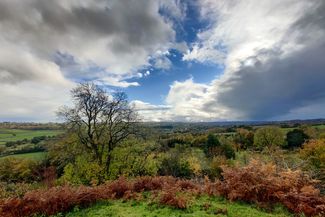
Spectacular views of Hay Bluff after the long ascent to Brilley Mountain.

Brilley Mountain and Painscastle

Visit Herefordshire Verified partner
-
 Brilley ChurchPhoto: Naomi Moyo-Wilson, Visit Herefordshire
Venturing into Powys, after a few hundred metres turn right towards Michaelchurch-on-Arrow and continue to Newchurch and the lovely St Mary’s Church, which boasts a 10th-century font and two of the oldest bells in Wales.
Turn left up the hill on the B4594 for the climb to Painscastle, set on a historic drovers’ road, where hilltop remains of a motte and bailey castle linger – though the refreshing ales at the old Roast Ox Inn might hold more appeal for thirsty cyclists.
Veer sharply east to tackle the steady climb towards Clyro Hill, bearing right pat Crowther’s Pool and back to Brilley Mountain. From here, retrace your tyre tracks back to Kington – where a well-deserved pint awaits at the Swan Hotel in Kington.
Visit Herefordshire Verified partner
Derived from the technical difficulty and the stamina requirements.
Track types
Rest stops
Border BeanNumber 25 Delicatessen
Tips and suggestions
Don't Miss: Spectacular views of Hay Bluff after the long ascent to Brilley Mountain.Border Bean
Number 25 Delicatessen
Nordic Walking in Kington
Lady Hawkins Community Leisure Centre
Hergest Ridge
Hergest Croft Gardens
Painscastle Castle
Public transport
Get Timetable to destination
Coordinates
Derived from the technical difficulty and the stamina requirements.
Statistics
- Content
- Show images Hide images