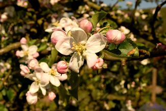
Look out for the traditional farmhouse orchards with their regular patterns of mature apple trees. Springtime brings a spectacular display of pinky-white blossom but there's interest throughout the year, including apples in autumn and mistletoe in winter. Our orchards are also home to a wide range of wildlife, including the rare Lesserspotted Woodpecker and iridescent Noble Chafer beetle. See what wildlife you can spot along the way.
Don't Miss
This walk starts in Woolhope, a pretty settlement which has built up around a 12th century church. The village sits in the Woolhope Dome, a rim of hills and folds resulting from the underlying geology of silurian limestone. This limestone rock is unusual - much of Herefordshire lies on old red sandstone - and creates a species-rich grassland habitat. Quite a few places in this locale and the county in general have the word ‘Hope’ in their name including Sollers Hope, Fownhope and of course Woolhope. The word ‘Hope’ means a small, enclosed ‘blind’ valley, and when you look at the hilly landscape in this area it is not surprising that the name appears so often.
Responsible for this content Visit Herefordshire
Verified partner
Enjoy Woolhope’s countryside on the Blossom Walk, where peaceful trails and springtime blooms await.
Photo: Dan Chubb, Visit Herefordshire
Selected alternatives for you
Look out for the traditional farmhouse orchards with their regular patterns of mature apple trees. Springtime brings a spectacular display of pinky-white blossom but there's interest throughout the year, including apples in autumn and mistletoe in winter. Our orchards are also home to a wide range of wildlife, including the rare Lesserspotted Woodpecker and iridescent Noble Chafer beetle. See what wildlife you can spot along the way.
moderate
Distance 6.1 mi
Duration2:30 h
Ascent344 ft
Descent348 ft
Highest point545 ft
Lowest point220 ft
This walk starts in Woolhope, a pretty settlement which has built up around a 12th century church. The village sits in the Woolhope Dome, a rim of hills and folds resulting from the underlying geology of silurian limestone. This limestone rock is unusual - much of Herefordshire lies on old red sandstone - and creates a species-rich grassland habitat. Quite a few places in this locale and the county in general have the word ‘Hope’ in their name including Sollers Hope, Fownhope and of course Woolhope. The word ‘Hope’ means a small, enclosed ‘blind’ valley, and when you look at the hilly landscape in this area it is not surprising that the name appears so often.
Author’s recommendation
For refreshments, head to one of the village's two welcoming pubs - The Crown and The Butcher's Arms, booking advisable if you would like to eat.
Responsible for this content
Visit Herefordshire
Verified partner
Difficulty
moderate
Overall difficulty
moderate
Derived from the technical difficulty and the stamina requirements.
Today {low} to {high} and {precipitation} of {precipitation_type}
show {x} more
Photo
Video
The Crown at Woolhope Woolhope Church - St. George's
Public transport
Public-transport-friendly
Woolhope is served by the 454 bus, which runs between Hereford and Woolhope. As this is a rural route, services may be limited, so it’s best to check the latest timetable before travelling.
Get Timetable to destination
to
Blossom Walk: Woolhope Circular
Parking
There is parking at Woolhope Village Hall and also a few spaces on Broadmoor Common.
Coordinates
OS Grid
SO 61161 35743
DD
52.018748, -2.567371
DMS
52°01'07.5"N 2°34'02.5"W
UTM
30U 529687 5763211
w3w
///redeeming.willing.boring
Get there by train, car, bike, or on foot!
Similar routes nearby
Marcle Ridge and Woolhope Dome
Marcle Ridge to Ross-on-wye
Blossom Walk: Westons Cider Circular
Herefordshire, Wye Valley, Willow Walk. Walking with Wheels
Ramble by the Wye
These suggestions were generated by our system
Difficulty
moderate
Overall difficulty
moderate
Derived from the technical difficulty and the stamina requirements.
Distance
6.1 mi
Duration
2:30 h
Ascent
344 ft
Descent
348 ft
Highest point
545 ft
Lowest point
220 ft
Public-transport-friendlyRound tripScenicRefreshment stops availableFamily-friendlyFloraFaunaDog-friendlySuitable for strollers
Statistics
Content
Show imagesHide images
Features
2D
3D
Maps and trails
Nothing selected - click and drag in the elevation profile to zoom
mift
Distance
Duration
Ascent
Descent
Elevation profile
Inspiration In Your Inbox
Sign up for trip ideas, inspiring itineraries, new walks and cycle trails, plus cultural and foodie highlights.