Starlit Stroll: Llangrove


Experience the magic of starwalking! Hike under cosmic skies, deep in the countryside near Ross-on-Wye, the gateway to the Wye Valley National Landscape.
Don't Miss
Beautifully peaceful, this remote - and very dark! - corner of the county is only really known to locals. Take in the stars as well as the sights and sounds of nocturnal nature as you walk five easy miles along footpaths which cross farmland and offer open views across the night-time landscape.
Return to the village of Llangrove for a well-earned pint and pub meal at the friendly Royal Arms (HR9 6EZ).

Starlit Stroll: Llangrove

Visit Herefordshire Verified partner
-
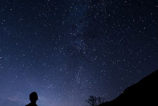
 Take a sparkling walk through Llangrove.Photo: Jake Weirick, CC0, Unsplash
Return to the village of Llangrove for a well-earned pint and pub meal at the friendly Royal Arms (HR9 6EZ).
Visit Herefordshire Verified partner
Derived from the technical difficulty and the stamina requirements.
Track types
Roadbook
Walk out of the village past the Royal Arms, going straight across at the T junction to join the footpath LG45. Follow that path giving views of open countryside until you get to Upper Park Farm Cattery, around the corner from Upper Fields. Walk past Upper Fields and look for a stile on your right which indicates the start of the footpath LG19. Go to the end of LG19 and at the road, turn right up the hill and look out for a footpath on your left, the LG35.
After a couple of fields, the footpath crosses a track but turn right up the track and you are now on the LG18. Walk up the track and rejoin the LG45 to get back to Treduchan Farm, Llangrove and the village. Instead of following the road, you could join the footpath LG15 by turning right in front of Treduchan Farm and looking for a stile in the hedge on your left, after a dip in the road. Keep bearing left and you will reach the main road through the village and after turning right, the Royal Arms is on your right.
Public transport
Get Timetable to destination
Coordinates

Derived from the technical difficulty and the stamina requirements.
Statistics
- Content
- Show images Hide images