Join Our Newsletter
Visit Herefordshire Radio
Blog Contact Us
Get Listed
© 2026 Herefordshire County BID

Ledbury to Marcle Ridge

Image
Ledbury
Map Marker Illustration
Ledbury
Wellies Illustration
7.5 miles
Intro

The trail begins on Herefordshire’s most easterly edge in Ledbury, moments away from the majestic Malvern Hills. Surrounded by woods, orchards and hills, Ledbury is a beautiful spot, characteristic of the county and beloved of literary luminaries from John Masefield to Elizabeth Barrett Browning. It is celebrated for its array of independent shops and its international poetry festival as well as its pretty jumble of historic buildings.

This section makes an excellent day hike, with return travel on the Daffodil Line bus - see itinerary.

Long-Distance Hikingrecommended routeLong-Distance Hiking  · Central England and the Midlands

The Herefordshire Trail - Section 1: Ledbury to Marcle Ridge

LogoVisit Herefordshire
Responsible for this content
Visit Herefordshire Verified partner 
  • Market House in Ledbury
    Market House in Ledbury
    Photo: Dan Chubb, Visit Herefordshire

Selected alternatives for you
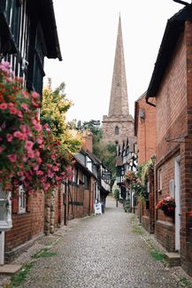
    A superbly scenic 154-mile loop around the county. The trail begins on Herefordshire’s most easterly edge in Ledbury, moments away from the majestic Malvern Hills. Surrounded by woods, orchards and hills, Ledbury is a beautiful spot, characteristic of the county and beloved of literary luminaries from John Masefield to Elizabeth Barrett Browning. It is celebrated for its array of independent shops and its international poetry festival as well as its pretty jumble of historic buildings.
    easy
    Distance 7.7 mi
    3:15 h
    515 ft
    167 ft
    623 ft
    148 ft
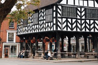
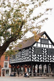
    Walkers will, in fact, start at the most iconic of these, the Market House. Sat on stilts in the centre of town, this black and white beauty is a 17th-century addition to a market dating from 1122. It trades every Tuesday and Saturday, suitable for picking up provisions to fuel the stretch ahead.

    From here, the route threads through town, soon reaching open country. It’s an extensive fruit growing area and much of the onward journey is through orchards, with tiny villages and historic buildings completing the scene. In Aylton, spot the thatched barn at Court Farm, which dates from 1503. It is supported by eight ‘crucks’ – huge naturally-curved oak timbers – and has an infill between its wall timbers of thinly-cut and woven oak stave (‘wattle’).

    In nearby Putley, you’ll pass through the former landscape park of the elegant Queen Anne-style mansion of Putley Court. Former resident, Squire Riley, pioneered quality fresh fruit production and dispatch by rail to the cities in the 1880s. Today, the local parishes celebrate their fruity heritage every autumn with the Big Apple Festival.

    A large depression on Marcle Ridge, The Wonder, is marked on the OS map. In 1575, a great landslip moved downhill engulfing all in its path. Kynaston Chapel, its churchyard, trees and cattle were swallowed up “to the astonishment of all beholders,” according to Tudor historian William Camden. Marcle Hill had indeed moved!

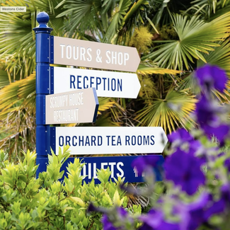
    It’s easy walking with fine views on Marcle Ridge, passing the 540-ft mast of Ridge Hill Transmitting Station. Then, downhill to Much Marcle village, pausing perhaps at local landmark, Weston’s Cider Mill. Cider and perry have been made here since the 1880s and it is still run by descendants of the founder. Book a tour or stop for a bite to eat.

    This section makes an excellent day hike, with return travel on the Daffodil Line bus.

    Author’s recommendation

    The leaflet for the route is available here.
    LogoVisit Herefordshire
    Responsible for this content
    Visit Herefordshire  Verified partner 
    Difficulty
    easy
    Overall difficulty
    easy

    Derived from the technical difficulty and the stamina requirements.

    Experience
    Landscape
    Highest point
    623 ft
    Lowest point
    148 ft
    Best time of year
    Jan
    Feb
    Mar
    Apr
    May
    Jun
    Jul
    Aug
    Sep
    Oct
    Nov
    Dec

    Track types

    Asphalt 28.19%Dirt road 1.34%Forested/wild trail 20.55%Path 41.66%Road 7.33%Unknown 0.90%
    Asphalt
    2.2 mi
    Dirt road
    548 ft
    Forested/wild trail
    1.6 mi
    Path
    3.2 mi
    Road
    2995 ft
    Unknown
    367 ft
    Show elevation profile
    Rest stop
    Tip
    Nearby
    Top Partner
    Waypoint
    Start point
    End point
    Low point
    High point
    Forecast
    Today {low} to {high} and {precipitation} of {precipitation_type}
    show {x} more
    Photo
    Video
    Market House
    The Lion Ledbury
    The Evolution Winery - 1276 Wines
    Blooms Sandwiches Ledbury

    Public transport

    Public-transport-friendly

    This section makes an excellent day hike, with return travel on the Daffodil Line bus

    Get Timetable to destination

    to
    The Herefordshire Trail - Section 1: Ledbury to Marcle Ridge

    Coordinates

    OS Grid
    SO 71083 37731
    DD
    52.037224, -2.422967
    DMS
    52°02'14.0"N 2°25'22.7"W
    UTM
    30U 539580 5765335
    w3w 
    ///cocoons.yards.horns
    Get there by train, car, bike, or on foot!

    Similar routes nearby

    • Three Choirs Way: British Camp - Staunton
    • The Herefordshire Trail - Section 2: Much Marcle to Ross-on-Wye
    • The Herefordshire Trail - Section 15: Fromes Hill to Ledbury
    • Herefordshire Trail: Fromes Hill to Ledbury
    • Wyche Way: Stage 5 Great Malvern to Upton upon Severn
     These suggestions were generated by our system
    Difficulty
    easy
    Overall difficulty
    easy

    Derived from the technical difficulty and the stamina requirements.

    Distance
    7.7 mi
    Duration
    3:15 h
    Ascent
    515 ft
    Descent
    167 ft
    Highest point
    623 ft
    Lowest point
    148 ft
    Public-transport-friendly Linear route Multi-stage route Scenic Refreshment stops available

    Statistics

    • Content
    • Show images Hide images
    Features
    2D 3D
    Maps and trails
    Nothing selected - click and drag in the elevation profile to zoom
    Distance
    Duration
    Ascent
    Descent
    Elevation profile