Join Our Newsletter
Visit Herefordshire Radio
Blog Contact Us
Get Listed
© 2026 Herefordshire County BID

Fromes Hill to Ledbury

Image
Ledbury
Map Marker Illustration
Fromes Hill
Wellies Illustration
10.1 miles
Intro

Shortly after crossing the A4103 over Fromes Hill, the trail walker can return to the peace of deep country and the quiet, unpaved byways of another era. In autumn, the old green lanes are fringed with blackberries and damson trees sprawling from hedgerows.

Long-Distance Hikingrecommended routeLong-Distance Hiking  · Herefordshire

The Herefordshire Trail - Section 15: Fromes Hill to Ledbury

LogoVisit Herefordshire
Responsible for this content
Visit Herefordshire Verified partner 
  • Walk from Fromes Hill to Ledbury, a peaceful countryside trail leading to one of Herefordshire’s prettiest market towns.
    Walk from Fromes Hill to Ledbury, a peaceful countryside trail leading to one of Herefordshire’s prettiest market towns.
    Photo: Trish Henderson, Visit Herefordshire

Selected alternatives for you
    Shortly after crossing the A4103 over Fromes Hill, the trail walker can return to the peace of deep country and the quiet, unpaved byways of another era. In autumn, the old green lanes are fringed with blackberries and damson trees sprawling from hedgerows.
    moderate
    Distance 10.5 mi
    4:20 h
    781 ft
    1,129 ft
    689 ft
    220 ft
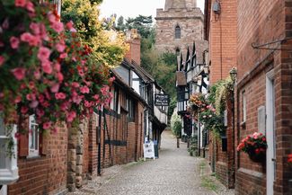
    In the Vale of Leadon, close to its little river, sits Bosbury, an important village with a wealth of listed buildings, including the fortress-like 13th-century detachedbell tower. Nationally rare, Herefordshire has more detached bell towers (seven) than any other county. They were built for defence as well as religion. The medieval Bishops of Hereford owned Bosbury manor - a remnant stone gateway survives of their former Bishops Palace, a favoured retreat. Nearby, a moated site of a Knights Templar preceptory is now Temple Court.

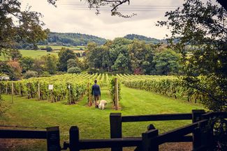
    The trail passes between rows of grapevines at Coddington Vineyard, which produces several English white wines and offers tastings and tours. Soon after, on 690-feet high Oyster Hill (the name of one of the wines) you can pause at a seat with a fine view.

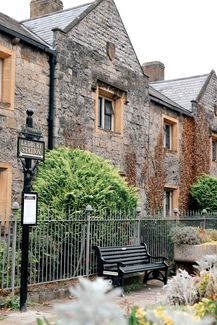
    Hope End (‘valley end’), a former deer park that once belonged to the Bishops, was the childhood playground of poet Elizabeth Barrett Browning (1806-1861).

    Here she honed her craft and, aged nine, was dubbed ‘Poet Laureate of Hope End’ by her father. The extravagant ‘Moorish-style’ house with minarets he spent years building was largely demolished and replaced within the century. Elizabeth loved the parkland which remains a scenic treasure. The woodlands were the setting of her poem The Lost Bower.

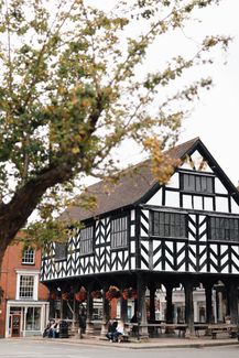
    Your path tracks the western edge of the Malvern Hills Area of Outstanding Natural Beauty, hills which inspired William Langland’s 14th century verse epic Piers Plowman and the music of 19th-century composer, Sir Edward Elgar. The trail ends at Ledbury, birthplace of the literary giant and former Poet Laureate John Masefield (1878-1967) who spoke with passion about his love of the local landscape.

    Author’s recommendation

    The leaflet for the route is available here.
    LogoVisit Herefordshire
    Responsible for this content
    Visit Herefordshire  Verified partner 
    Difficulty
    moderate
    Overall difficulty
    moderate

    Derived from the technical difficulty and the stamina requirements.

    Experience
    Landscape
    Highest point
    689 ft
    Lowest point
    220 ft
    Best time of year
    Jan
    Feb
    Mar
    Apr
    May
    Jun
    Jul
    Aug
    Sep
    Oct
    Nov
    Dec

    Track types

    Asphalt 21.31%Dirt road 4.02%Forested/wild trail 5.08%Path 63.43%Road 6.13%
    Asphalt
    2.2 mi
    Dirt road
    2228 ft
    Forested/wild trail
    2812 ft
    Path
    6.6 mi
    Road
    0.6 mi
    Show elevation profile
    Rest stop
    Tip
    Nearby
    Top Partner
    Waypoint
    Start point
    End point
    Low point
    High point
    Forecast
    Today {low} to {high} and {precipitation} of {precipitation_type}
    show {x} more
    Photo
    Video
    Hope End Walled Garden
    Oyster Hill
    Coddington Court
    Coddington Church
    The Farmers Arms
    Market House
    Coddington Vineyard

    Public transport

    Get Timetable to destination

    to
    The Herefordshire Trail - Section 15: Fromes Hill to Ledbury

    Coordinates

    OS Grid
    SO 67686 46636
    DD
    52.117098, -2.473328
    DMS
    52°07'01.6"N 2°28'24.0"W
    UTM
    30U 536061 5774193
    w3w 
    ///excellent.wished.jogged
    Get there by train, car, bike, or on foot!

    Similar routes nearby

    • Herefordshire Trail: Fromes Hill to Ledbury
    • Wyche Way: Stage 4 Bishops Frome to Great Malvern
    • The Herefordshire Trail - Section 1: Ledbury to Marcle Ridge
    • Wyche Way: Stage 5 Great Malvern to Upton upon Severn
    • Three Choirs Way: British Camp - Staunton
     These suggestions were generated by our system
    Difficulty
    moderate
    Overall difficulty
    moderate

    Derived from the technical difficulty and the stamina requirements.

    Distance
    10.5 mi
    Duration
    4:20 h
    Ascent
    781 ft
    Descent
    1,129 ft
    Highest point
    689 ft
    Lowest point
    220 ft
    Linear route Multi-stage route Scenic Refreshment stops available Family-friendly Flora Fauna Dog-friendly

    Statistics

    • Content
    • Show images Hide images
    Features
    2D 3D
    Maps and trails
    Nothing selected - click and drag in the elevation profile to zoom
    Distance
    Duration
    Ascent
    Descent
    Elevation profile