Join Our Newsletter
Visit Herefordshire Radio
Blog Contact Us
Get Listed
© 2026 Herefordshire County BID

Leintwardine to Richards Castle

Image
Downton Gorge Bridge
Map Marker Illustration
Leintwardine
Wellies Illustration
13.3 miles
Intro

The path from the Teme Valley heads up steep Shelderton Hill which rises to more than 1,000 ft and bears east, past remaining hillside fragments of the former Royal Forest of Mocktree, a once vast medieval hunting forest spanning the Herefordshire/Shropshire border. In the 17th century, the woodlands were leased to ironmasters to coppice wood for charcoal.

Long-Distance Hikingrecommended routeLong-Distance Hiking  · Central England and the Midlands

The Herefordshire Trail - Section 11: Leintwardine to Richards Castle

LogoVisit Herefordshire
Responsible for this content
Visit Herefordshire Verified partner 
  • Forge Bridge
    Forge Bridge
    Photo: Naomi Moyo-Wilson, Visit Herefordshire

Selected alternatives for you
    The path from the Teme Valley heads up steep Shelderton Hill which rises to more than 1,000 ft and bears east, past remaining hillside fragments of the former Royal Forest of Mocktree, a once vast medieval hunting forest spanning the Herefordshire/Shropshire border. In the 17th century, the woodlands were leased to ironmasters to coppice wood for charcoal.
    moderate
    Distance 13.9 mi
    6:05 h
    1,601 ft
    1,729 ft
    1,007 ft
    308 ft
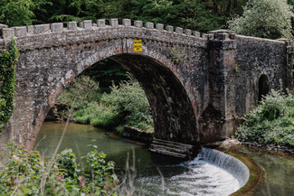
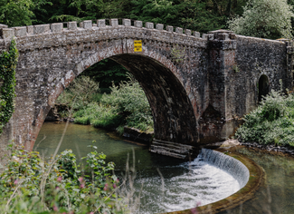
    Bringewood Forge’s iron smelting furnace and forges stood by the Teme, close to Forge Bridge and its elegant horseshoe weir. Energised on its passage through Downton Gorge, the river drove waterwheels for bellows and trip hammers. Mule trains brought in iron ore and charcoal and then carried away finished iron. When it ceased production in 1815, Bringewood was the last major charcoal-fuelled ironworks in England.

    Along the riverbank, look our for Downton Castle, built on the profits of iron by Richard Payne Knight MP (1750-1824), grandson of the Bringewood ironmaster Richard Knight (1659-1745). Payne Knight, a classical scholar, was an enthusiast of the ‘picturesque’ school. His inherited estate was all he could have hoped for.

    Part of it is now a designated Site of Special Scientific Interest (SSSI), Downton Gorge National Nature Reserve. Its ancient woodland is a remaining fragment of Bringewood Chase, a largely upland former royal forest. In winter, colliers toiled to make charcoal and mules descended steep tracks to carry fuel to the ironworks.

    The trail heads over Hunstay Hill and through a forest tract to the Church of St. George, Burrington. Its rare churchyard cluster of cast-iron grave-slabs, the earliestdated 1619, are the monuments of the Teme Valley ironmasters and their families, the Knights among them.

    Along the trail is the former home of a celebrated member of the family. Elton Hall, beside the hamlet’s tiny Norman church, was the home and ‘laboratory’ of pioneer horticulturalist and plant breeder Thomas Andrew Knight (1759-1838). Charles Darwin, in On the Origin of Species, paid credit to Herefordshire-born Knight for his ground-breaking research into plant physiology.

    Author’s recommendation

    The leaflet for the route is available here.
    LogoVisit Herefordshire
    Responsible for this content
    Visit Herefordshire  Verified partner 
    Difficulty
    moderate
    Overall difficulty
    moderate

    Derived from the technical difficulty and the stamina requirements.

    Experience
    Landscape
    Highest point
    1007 ft
    Lowest point
    308 ft
    Best time of year
    Jan
    Feb
    Mar
    Apr
    May
    Jun
    Jul
    Aug
    Sep
    Oct
    Nov
    Dec

    Track types

    Asphalt 16.76%Forested/wild trail 24.66%Path 58.57%
    Asphalt
    2.3 mi
    Forested/wild trail
    3.4 mi
    Path
    8.1 mi
    Show elevation profile
    Rest stop
    Tip
    Nearby
    Top Partner
    Waypoint
    Start point
    End point
    Low point
    High point
    Forecast
    Today {low} to {high} and {precipitation} of {precipitation_type}
    show {x} more
    Photo
    Video
    Richards Castle St Bartholomew Church & 11th Century Castle
    The Lion Leintwardine

    Public transport

    Get Timetable to destination

    to
    The Herefordshire Trail - Section 11: Leintwardine to Richards Castle

    Coordinates

    OS Grid
    SO 40456 74047
    DD
    52.361235, -2.875805
    DMS
    52°21'40.4"N 2°52'32.9"W
    UTM
    30U 508457 5801224
    w3w 
    ///excavate.elevates.tablets
    Get there by train, car, bike, or on foot!

    Similar routes nearby

    • The Herefordshire Trail - Section 10: Lingen to Leintwardine
    • The Herefordshire Trail - Section 12: Richards Castle to Leominster
    • The Mortimer Trail
    • The Herefordshire Trail - Section 13: Leominster to Edwyn Ralph
    • The Herefordshire Trail - Section 9: Kington to Lingen
     These suggestions were generated by our system
    Difficulty
    moderate
    Overall difficulty
    moderate

    Derived from the technical difficulty and the stamina requirements.

    Distance
    13.9 mi
    Duration
    6:05 h
    Ascent
    1,601 ft
    Descent
    1,729 ft
    Highest point
    1007 ft
    Lowest point
    308 ft
    Linear route Multi-stage route Scenic Cultural/historical interest Geological highlights Flora Fauna

    Statistics

    • Content
    • Show images Hide images
    Features
    2D 3D
    Maps and trails
    Nothing selected - click and drag in the elevation profile to zoom
    Distance
    Duration
    Ascent
    Descent
    Elevation profile