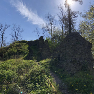
The castle ruins on the hill above the village of Richards Castle are all that remains of the once-formidable centrepiece of England’s earliest enclosed Norman Borough.
It was one of only four pre-conquest Norman fortresses and possibly Britain’s oldest stone castle. A long-vanished, but once substantial, octagonal keep and curtain walls with D-shaped watch towers, replaced wooden defences erected in about 1050 by Richard Le Scrope, a Norman favourite of King Edward the Confessor.
The development angered the local Anglo-Saxon nobility - and one ‘Eric the Wild’ (Eric Silvaticus) in particular. As the Norman grip tightened, Eric’s lands were ravaged. He joined forces with the Welsh kings to lead a rebellion. The allies laid waste to much of Norman Herefordshire and attacked Hereford Castle. The Richards Castle stronghold was a ruin by the 17th century but was the site of a clash of forces in the English Civil War.
The trail then heads through Orleton, a walker-friendly village with two pubs and a shop. It crosses a surviving fragment of the former Leominster-Stourport Canal and on through a patchwork of flat fields and the churchyard of the fine Norman church at Eye hamlet.
The Balance Inn, Luston, stands at the former site of a weigh-station where the valuable fleeces of the local Ryeland sheep flocks were once weighed. The fine, long-staple wool was favoured by Elizabeth I who insisted her stockings must be made from ‘Leominster Ore,’ as it was known.
The trail then passes Scatterbrain, a name reflecting the often-violent history of the border country. In 1461, during the Wars of the Roses, the Battle of Mortimer’s Cross began five miles away, but the bloody conflict which claimed the lives of 4,000 men, rippled through the Lugg Valley. Battle raged across these fields once more in 1645. Royalists led by Sir William Croft of nearby Croft Castle, were defeated by the Roundheads led by Colonel John Birch and prevented from recapturing Leominster.