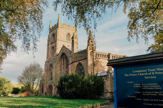
Ornate 12th-century stone carving at the west door of Leominster Priory Church echoes other outstanding examples of the Herefordshire School of Romanesque Sculpture seen on the trail at Kilpeck and Eardisley.
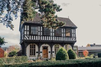
The grand scale of the Leominster church hints at medieval prosperity yet the Priory’s position was sometimes precarious. Its black-robed Benedictine prior and monks presided over an agricultural empire of 16 manors, a ‘cash cow’ for the larger Reading Abbey founded by Henry I (where the king planned to be buried). The priory struggled and was involved in a dispute with a local moneylender. Nearby, Grange Court is a fine example of Herefordshire’s timber-framed architecture. Beatuifully carved, it is the work of John Abel, known as the King’s carpenter.
Following the River Lugg downstream, the trail heads east over low hills to Bache Camp for a gentle journey through undulating countryside. A series of three lovely medieval churches acts as landmarks.
Pudleston’s St. Peters dating from 1200, has a distinctive tower capped by a pyramidical roof and oak-shingled spire. Two gnarled old characters stand in a field by the church: ‘Adam and Eve’ are among the county’s oldest oak trees.
St. Leonards, Hatfield, one of Herefordshire’s three oldest churches, is of Saxon origin and is mentioned in the Domesday Book. Some herringbone masonry, a Saxon font and blocked Saxon doorway attest to its pedigree.
The stonework includes locally quarried tufa, a porous white rock. A Georgian gallery reached by a narrow staircase provides a close-up view of beautiful medieval timberwork above the nave.
The trail crosses the River Frome, just a stream here in its upper reaches. To the north is another iron age hillfort, Wall Hills. A mile on, the stocky tower of the 12th-century Edwyn Ralph Church contains a remarkable group of medieval stone effigies. Nearby, Moat Field is the former site of a castle and settlement deserted after the Black Death swept England in 1348.