Join Our Newsletter
Visit Herefordshire App Blog Contact Us
Get Listed
© 2026 Herefordshire County BID

The Lugg Valley Loop

Image
ancient bridge with river flowing through, trees to one side and bright blue skies
Wellies Illustration
5.6 miles
Paw Print Illustration
Ending Pub is Dog Friendly
Intro
Enjoy a gentle amble along the banks of the River Lugg, exploring stunning water meadows, taking in wide-open skies, and looking out to striking hills in the distance.

Don't Miss

The ancient floodplains of the River Lugg are home to a host of wildlife native to Britain, including the elusive but beloved kingfisher - keep your eyes peeled for that bright blue flash along the water.

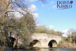
Take note of Moreton Bridge, a sturdy stone testament to the route's history as a key trading path dating back to the 16th Century. For a culture fix, pop into not one, but two 12th Century churches in Sutton St Nicholas, each offering a unique window into the region's medieval past. Finally, round off your ramble by booking a table for a roast en route at Lyde Court, renowned locally for its outstanding Sunday carvery.


(Photography: "Moreton Bridge" by Philip Pankhurst is licensed under CC BY-SA 2.0 / Source: Geograph.org.uk)

Hiking Trail recommended route Hiking Trail  · Central England and the Midlands

The Lugg Valley Loop

Logo Visit Herefordshire
Responsible for this content
Visit Herefordshire Verified partner 
  • St Nicholas Church, Sutton St Nicholas.
    St Nicholas Church, Sutton St Nicholas.
    Photo: Philip Pankhurst, commons.wikimedia.org

Selected alternatives for you
    An easy 9km/5.6 miles across fields, gentle inclines, couple of high/rickety stiles, no cows! 
    moderate
    Distance 5.6 mi
    2:10 h
    164 ft
    164 ft
    299 ft
    171 ft
    From St. Andrew's Church over the River Lugg, rigth across fields to the Golden Cross (50 minutes) for a rest and a drink (open 12:00 every day except Mondays); on to Lyde Court (60 minutes) for lunch (open 10:00-16:00 Thursday-Sunday); back to Moreton on the bridleway over the new bridge (50 minutes). 

    Author’s recommendation

    Bridleway can get muddy after rain.
    Logo Visit Herefordshire
    Responsible for this content
    Visit Herefordshire  Verified partner 
    Difficulty
    moderate
    Overall difficulty
    moderate

    Derived from the technical difficulty and the stamina requirements.

    Experience
    Landscape
    Highest point
    299 ft
    Lowest point
    171 ft
    Best time of year
    Jan
    Feb
    Mar
    Apr
    May
    Jun
    Jul
    Aug
    Sep
    Oct
    Nov
    Dec

    Track types

    Asphalt 7.39%Forested/wild trail 12.30%Path 57.48%Road 22.81%
    Asphalt
    2182 ft
    Forested/wild trail
    0.7 mi
    Path
    3.2 mi
    Road
    1.3 mi
    Show elevation profile

    Rest stops

    Lyde Court Café
    Rest stop
    Tip
    Nearby
    Top Partner
    Waypoint
    Start point
    End point
    Low point
    High point
    Forecast
    Today {low} to {high} and {precipitation} of {precipitation_type}
    show {x} more
    Photo
    Video
    Lyde Court Café

    Public transport

    Get Timetable to destination

    to
    The Lugg Valley Loop

    Coordinates

    OS Grid
    SO 53417 45319
    DD
    52.104237, -2.681522
    DMS
    52°06'15.3"N 2°40'53.5"W
    UTM
    30U 521812 5772679
    w3w 
    ///tabs.describe.hedge
    Get there by train, car, bike, or on foot!

    Equipment

    Walking boots.

    Similar routes nearby

    • Breinton Springs
    • Blossom Walk: Woolhope Circular
    • Marcle Ridge and Woolhope Dome
    • Marcle Ridge to Ross-on-wye
    • Wine Walk: Frome Valley
     These suggestions were generated by our system
    Difficulty
    moderate
    Overall difficulty
    moderate

    Derived from the technical difficulty and the stamina requirements.

    Distance
    5.6 mi
    Duration
    2:10 h
    Ascent
    164 ft
    Descent
    164 ft
    Highest point
    299 ft
    Lowest point
    171 ft
    Round trip

    Statistics

    • Content
    • Show images Hide images
    Features
    2D 3D
    Maps and trails
    Nothing selected - click and drag in the elevation profile to zoom
    Distance
    Duration
    Ascent
    Descent
    Elevation profile