Join Our Newsletter
Visit Herefordshire Radio
Blog Contact Us
Get Listed
© 2026 Herefordshire County BID

Weobley to Pembridge

Image
Quaint Herefordshire village scene with houses and a church
Map Marker Illustration
Weobley
Wellies Illustration
7.9 miles
Intro

This walk takes in some of Herefordshires famous black & white villages, linked together by gentle strolls along quintessential country lanes and across picturesque green farmland. It's a route not to be rushed, make sure you plan in pit-stop time and and explore each village (even if it's just for a quick pint!). 

Don't Miss

Weobley
The Castle, a motte and bailey, thought to have been built soon after the Norman conquest. The impressive church of St Peter and St Paul, with the second tallest spire in the county. Traditional Tudor buildings aplenty, look out for the ‘heritage trail’ signs dotted around the village. Head to the brilliantly named and newly opened Wobbly Badger Cafe, 17th Century New Unicorn pub, Ye Old Salutation Inn or Green Bean Cafe (a favourite of cast and crew during Hamnet filming) for refreshment before setting off.

Dilwyn
Exquisite examples of half-timbered buildings, the oldest of which is thought to be Church House, a cottage dating back to the 14th century. St Mary the Virgin Church, a Grade I listed building which dates back to the 12th century and still features some surviving elements of Norman design. 
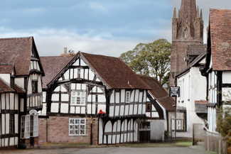
Eardisland 
Thatched examples of black & white houses. Stand on the bridge to see the Old School House (complete with whipping post!) and the Manor House. Pop into the community shop in the unusual 17th-century riverside dovecote. There’s a moated castle mound and an impressive medieval church too. Don't miss Rita's Tea Room for a mid-way sugar-hit.

Pembridge
Timber-framed buildings line the main street of this vibrant, quintessentially English village with the house names giving away the buildings’ original uses. Seek out the 16th century Market Hall and amazing pagoda-style belfry at St Mary's Church. Peruse modern art & craft at Old Chapel Gallery. Enjoy delicious food at the nearby Cider Barn Restaurant or 700-year-old New Inn.
 

Hiking Trailrecommended routeHiking Trail  · Central England and the Midlands

Weobley to Pembridge

LogoVisit Herefordshire
Responsible for this content
Visit Herefordshire Verified partner 
  • Pembridge
    Pembridge
    Photo: Dan Chubb, Visit Herefordshire

Selected alternatives for you
    This walk takes in some of Herefordshires famous black & white villages, linked together by gentle strolls along quintessential country lanes and across picturesque green farmland. 
    difficult
    Distance 8 mi
    3:10 h
    295 ft
    233 ft
    387 ft
    266 ft

    Author’s recommendation

    It's a route not to be rushed, make sure you plan in pit-stop time and and explore each village (even if it's just for a quick pint!). 
    LogoVisit Herefordshire
    Responsible for this content
    Visit Herefordshire  Verified partner 
    Difficulty
    difficult
    Overall difficulty
    difficult

    Derived from the technical difficulty and the stamina requirements.

    Experience
    Landscape
    Highest point
    387 ft
    Lowest point
    266 ft
    Best time of year
    Jan
    Feb
    Mar
    Apr
    May
    Jun
    Jul
    Aug
    Sep
    Oct
    Nov
    Dec

    Track types

    Asphalt 36.72%Dirt road 0.54%Forested/wild trail 1.77%Path 55.10%Road 5.85%
    Asphalt
    2.9 mi
    Dirt road
    230 ft
    Forested/wild trail
    748 ft
    Path
    4.4 mi
    Road
    2470 ft
    Show elevation profile

    Rest stops

    The New Inn
    Jules Restaurant
    Rita’s Tearoom
    Green Bean Cafe

    Roadbook

    The walk starts from Bell Square Car Park in Weobley (HR4 8SE). If the car park is full there is further free parking available at the village hall on the other side of the village (HR4 8SN).

    Walk left out of Bell Square Car Park, then take the first left up Church Road, heading toward the St Peter and St Paul church. Continue past the church, staying on the road until you reach a large double-gate with a pedestrian gate alongside it. Go through this gate and follow the track for 50m, then take the wooden pedestrian gate on your left and follow a bridleway up the field with the hedgerow to your right (taking care not to walk up the more obvious track).

    After about 1.2km you'll pass a large stone animal shelter. Before joining a farm track that dips down into the brook, turn to your left and head towards a gate where two hedges converge. After passing through the gate, follow the footpath north-east for about 500m until you get to the road.

    Now walk along the lane until you reach Dilwyn. Walk through the village and leave it on the northerly road with the churchyard on your left. When you get to the A4112, carefully cross the main road and head up the lane on the opposite side of the road.

    After about 300m on the lane, turn right at a t-junction then keep walking until you reach a crossroads. Turn right at the crossroads, then left when you reach the next t-junction. Follow this straight road for about 600m and then turn right at the junction. The lane you’re on snakes for about 700m until you take a marked public footpath on the left which goes up a property's track.

    At the end of the track look out for a public footpath on the right (immediately after the house) and follow the path north-east across two small fields and one larger field to where to crosses the A44. Cross the road carefully on this fast bend and go over the stile that's facing you. The footpath follows the left-hand boundary of the farm buildings and then crosses a small country lane. After crossing the lane, walk to the end of the field and then turn left. This footpath will now lead you north into Eardisland.

    As you leave Eardisland, take the footpath on your right about 50m after the White Swan. This clear and well trodden footpath will now lead you west, across fields and all the way to Pembridge. Upon reaching Bridge Street, turn left and follow the road into the village centre.

    Rest stop
    Tip
    Nearby
    Top Partner
    Waypoint
    Start point
    End point
    Low point
    High point
    Forecast
    Today {low} to {high} and {precipitation} of {precipitation_type}
    show {x} more
    Photo
    Video
    Old Chapel Gallery
    The New Inn
    Jules Restaurant
    Rita’s Tearoom
    Green Bean Cafe

    Public transport

    Get Timetable to destination

    to
    Weobley to Pembridge

    Parking

    Bell Square Car Park in Weobley (HR4 8SE). If the car park is full there is further free parking available at the village hall on the other side of the village (HR4 8SN).

    Coordinates

    OS Grid
    SO 40165 51736
    DD
    52.160641, -2.876116
    DMS
    52°09'38.3"N 2°52'34.0"W
    UTM
    30U 508474 5778912
    w3w 
    ///head.promotion.photocopy
    Get there by train, car, bike, or on foot!

    Equipment

    Walking shoes.

    Similar routes nearby

    • Weobley Trail
    • Black & White Villages Walk: Weobley to Burton Hill
    • Black & White Villages Walk: Eardisland to Shobdon Arches
    • Whittern Farms Trail (Private Property - guests only)
    • Titley Round
     These suggestions were generated by our system
    Difficulty
    difficult
    Overall difficulty
    difficult

    Derived from the technical difficulty and the stamina requirements.

    Distance
    8 mi
    Duration
    3:10 h
    Ascent
    295 ft
    Descent
    233 ft
    Highest point
    387 ft
    Lowest point
    266 ft
    Linear route Refreshment stops available

    Statistics

    • Content
    • Show images Hide images
    Features
    2D 3D
    Maps and trails
    Nothing selected - click and drag in the elevation profile to zoom
    Distance
    Duration
    Ascent
    Descent
    Elevation profile