Introducing Alfred Watkins, a fascinating man
The originator of ley lines theory & inspiration for the Watkins Way
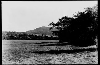
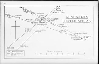
On June 30 1921 Alfred Watkins had an extraordinary revelation. As he stood on a Herefordshire hillside, it came to him that straight lines of sight criss-crossed the landscape, connecting ancient and spiritual sites. He christened them ley lines and regarded them as we might imagine a Neolithic Sat Nav – straight tracks enabling our ancestors to situate themselves in the landscape and navigate through it. We know our forebears travelled for trade, rituals and celebrations, perhaps these alignments unveiled how such a feat had been made possible. Ley lines have fascinated us ever since and have served as the inspiration for Visit Herefordshire's scenic roadtrip and cycling route The Watkins Way. But who was Alfred Watkins and how did he come to make this discovery?
Quote
First and foremost he was a Herefordshire Man, as native to the county as the hop and the apple.
Born and bred Herefordian
An enthusiastic antiquarian, inventor and pioneer photographer, Alfred Watkins was a born and bred Herefordian who knew the county's byways like the back of his hand. He was born in the city on 27 January 1855 at the Imperial Inn, a pub on Widemarsh Street which still stands today. His father was a classic Victorian entrepreneur who expanded the 'Imperial Empire', establishing a brewery and flour mill. Meanwhile, Alfred travelled the length and breadth of Herefordshire, taking orders for the family business. He also brought the first electric light to the county when he installed a dynamo at the flour mill.
Lover of the local landscape
The local landscape ignited something in Alfred. He was passionate about documenting rural life and a sense of place through photography. For over sixty years he photographed everything from significant local events and heritage sites to ancient trees and a variety of countryside activities. Thanks to him, we have a fine record of many archaeological sites which have since suffered over time, such as Craswall Priory and sections of Hereford's City Walls. Watkins' images (and walking routes) featured in guide books and his work has even been shown at the Tate in London in recent years. Watkins was also passionate about preserving heritage buildings and was involved in protecting the Black and White House, now a museum in Hereford, as well as the Market House in Pembridge. He also loved the River Wye and was captain of the Hereford Rowing Club. He even named one of his prized flours Vagos, taken from the Roman name for river - Vaga, meaning 'wandering maiden'.
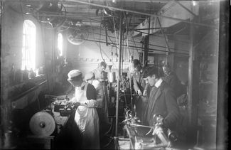
Pioneering inventor
Watkins' strong interest in photography began in his late teens and he possessed a good practical understanding of the issues around determining the correct exposure and development times. To overcome the former, he invented a type of pocket calculator which he manufactured and sold from his base in Hereford. He then created a more cost-effective version, known as the Bee Meter which was sold all over the world. A Bee Meter was even used by Ponting in 1910 during Scott's Antarctic expedition. Watkins became a Fellow of the Royal Photographic Society in 1910 and was awarded for his research work. He went on to write a highly regarded manual for amateur photographers.
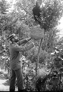
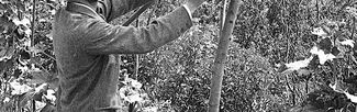
Keen Beekeeper
Watkins' interest in bees was not limited to the Bee Meter. He was also a founding member of the Hereford Bee-Keepers Association which had a horse-drawn ‘Bee Van’ which travelled around the county's villages, teaching the best methods of beekeeping. In the evening, these talks were illustrated with magic lantern shows.
Developing the ley lines theory
He was also a lifelong member of the esteemed Woolhope Naturalists' Field Club which studies local geology, natural history and antiquities. During his presidency in 1919, he tried (unsuccessfully) to permit women to join. It was with this group that he first shared his theories about ley lines, following his revelation on a hillside near Hereford. The concept of 'straight tracks' pulled together Watkins' interests in geography, history and archaeology. He devoted considerable time to fieldwork, identifying alignments and also using photography and mapped measurements to evidence the existence of leys. He first presented his ideas at a meeting of the Woolhope Naturalists in September 1921 and went on to publish his first book Early British Trackways in 1922. Pulling together his geographical and historical knowledge, he went on to expound his ley lines theory in The Old Straight Track.
An intriguing concept
Watkins’ concept has had an enormous impact. In the 1920s and 1930s it drove thousands of people to the countryside in search of the straight tracks and Watkins even published The Ley Hunters Manual in 1927 to guide their efforts. Meanwhile, a 1960s revival led by John Michell's book The View Over Atlantis gave Watkins' theory a mystical twist, even featuring UFOs. Then, in the 1970s ley lines were said to influence the land art movement and artists such as Richard Long and Hamish Fulton. Still in print, Watkins' book and the concept of ley lines will no doubt continue to intrigue.


